Aerial Survey
Aerial Survey captures land data using drones or aircraft, providing detailed images and maps for large-scale projects like land development, agriculture, and environmental monitoring.

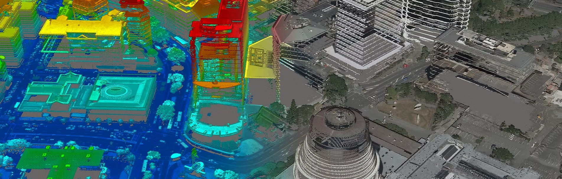
LiDAR Capture
LiDAR Capture
Why choose alisteshaar Aerial surveys
drone industry
In Saudi Arabia, experience is essential, especially when navigating the diverse terrain and changing weather conditions. As the most experienced player in the drone industry, Alisteshaar brings unmatched expertise to the sky and on the ground.
Risk Factors
With a strong client focus and a solid reputation in Saudi Arabia, we ensure you minimize risk by partnering with experts who truly understand the unique challenges of the region. At Alisteshaar, we take pride in going the extra mile to deliver exceptional results for our clients.
Quality
The top feedback we consistently receive from our clients is that our products are of the highest quality. Our team is committed to maintaining rigorous production processes and quality assurance checks to guarantee reliable and consistent results every time.
Saudi Owned
We are proudly based, owned, and operated in Saudi Arabia. Why is this important? Saudi Arabia’s diverse geography and vast landscapes make it a unique location for aerial capture. Being based here allows us to swiftly respond to our clients’ needs and capture opportunities in line with the Kingdom.

We strictly adhere to all flying rules and regulations, ensuring our drone services comply with local laws in every region, including Riyadh, Jeddah, Dammam, and other cities across Saudi Arabia. Our operations are conducted in full compliance with regulations for urban, rural, and restricted areas, such as no-fly zones near airports, military sites, and government buildings. By following these rules and safety standards, we guarantee the legality, safety, and professionalism of our services, ensuring that each flight meets the highest regulatory requirements.

Our operations are authorized by the General Authority of Civil Aviation (GACA) in Saudi Arabia, the official authority overseeing aviation safety and regulations within the Kingdom. We take all necessary steps to secure permits and approvals through GACA, ensuring every drone survey is carried out with full legal compliance. This involves meticulous planning, documentation, and adherence to all guidelines and conditions set forth by GACA. By maintaining this high standard of regulatory compliance, we ensure that our drone operations are safe, reliable, and conducted with the utmost professionalism, meeting the expectations of both our clients and governing authorities.

Our drone operations are conducted with strict compliance to the designated flying zones in Saudi Arabia: red, yellow, and green. Red zones, such as airports, military areas, and sensitive locations, are strictly off-limits, and we ensure these areas are completely avoided. In yellow zones, where operations require prior approval, we secure all necessary permissions and follow additional safety measures to operate responsibly. Green zones, which permit drone activities, are managed with the utmost professionalism, adhering to all safety and operational guidelines. This meticulous approach ensures our services are safe, legal, and compliant in every area we operate.
 surveys")
Drone (UAV) surveys
We provide advanced drone (UAV) survey services in Riyadh, Saudi Arabia, delivering exceptional accuracy and efficiency across a wide range of industries. Our state-of-the-art unmanned aerial vehicles (UAVs), equipped with high-resolution cameras and sensors, ensure centimeter-level precision in geospatial data. Our services cater to various applications such as construction surveying, infrastructure development, mining, and agriculture. Ideal for topographic mapping, land surveys, progress monitoring, and environmental assessments, we offer detailed aerial imagery and 3D models that meet the highest accuracy standards. Whether you need drone-based surveying solutions for construction, real estate mapping, or geospatial data collection for environmental studies, our drone surveys provide reliable and accurate results
Satellite image processing
At Alisteshaar Geospatial Consultants, we specialize in satellite image processing services to deliver accurate, detailed geospatial data for a wide range of applications in Saudi Arabia and beyond. Using advanced processing techniques, we transform high-resolution satellite imagery into actionable insights for industries such as urban planning, environmental monitoring, and agriculture. Our services include orthorectified images, land cover classification, change detection, and topographic mapping, ensuring precise and reliable results. Whether you’re monitoring environmental changes, assessing infrastructure development, or performing land-use analysis, our satellite image processing solutions empower you to make informed decisions with confidence.


Photogrammetry
At Alisteshaar Geospatial Consultants, we specialize in photogrammetry services to deliver precise 3D models, maps, and topographic data for various applications. Using advanced techniques to process aerial imagery and satellite photos, we provide accurate geospatial information essential for industries such as construction, urban planning, and environmental monitoring. Our photogrammetry solutions offer high-resolution spatial data that supports project planning, land surveys, and infrastructure development in Saudi Arabia and beyond. With our reliable and high-quality data, we empower businesses to make informed decisions, optimize resources, and ensure efficient and sustainable development.
Orthophotos
Orthophotos are essential for providing accurate, distortion-free representations of the Earth’s surface. At Alisteshaar Geospatial Consultants, we ensure these images meet the highest standards of quality. Using advanced photogrammetry techniques, we process aerial and satellite imagery into precise, georeferenced orthophotos, perfect for land mapping, urban planning, and environmental monitoring. With centimeter-level accuracy, our detailed orthophotos help clients in Saudi Arabia and beyond with site analysis, infrastructure development, and land-use planning. These high-quality images are an indispensable tool for effective decision-making and efficient project execution.


Why Use Vision Aerial Drones for Surveying & Mapping?
Reach Remote Areas
Better Data
Cost Effective
Simplify Work Flow
Precise Data
View our Data